
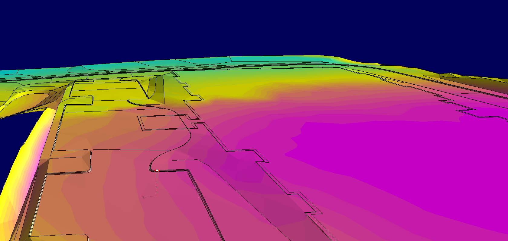
Optimized for construction operations, Gradework enhances AGTEK’s familiar estimating interface for use in planning work, modeling grade, and measuring project progress. Gradework readily interprets point clouds and orthomosaic images from UAV / drone flights—as well as processing progress topo surveys from GPS, Total Stations or laser scanners —into progress surfaces for calculating production quantities that provide fast, objective feedback about what has been accomplished on site and what may need attention before it is too late.
Gradework gives you the power to visualize and edit the GPS models your machine control systems are working toward, calculate quantities and balance cut- fill areas for your hauls to ensure you get the most out of you heavy equipment.
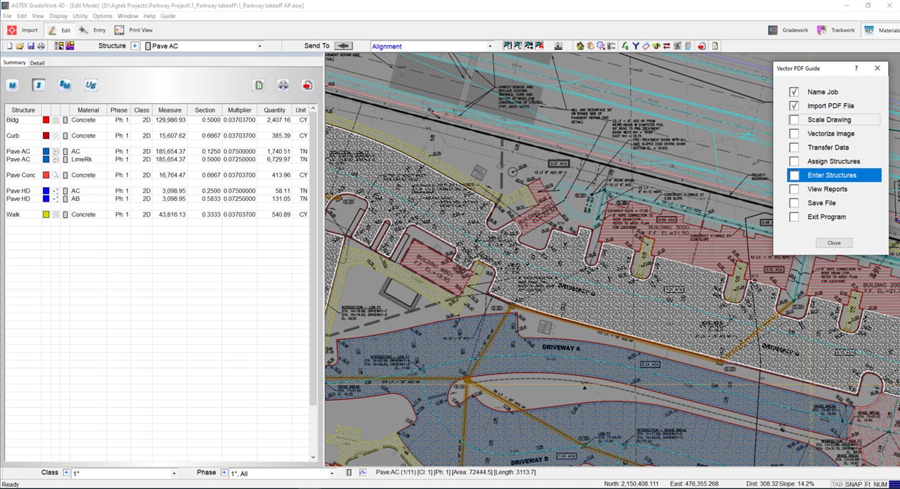
A graphical, on-screen takeoff system for contractors, Materials combines intuitive data entry with flexible reporting and integration with your Gradework dirt takeoff to speed your estimates of construction materials.
Integrated with Gradework, Materials allows entry on-screen from TIF, PDF or CAD and shares with your dirt takeoff whether done first or later. Materials measures areas, lengths and counts, and extends them into yards of concrete, tons of asphalt, lengths of guard rail, counts of your lights, and other cost items.
Materials reports and exports spreadsheet data by structure, material and phase of construction, and generates comprehensive geo-referenced graphical reports that can be emailed as PDFs, displayed on Google Earth or navigated on-site using your iPhone or Android device.
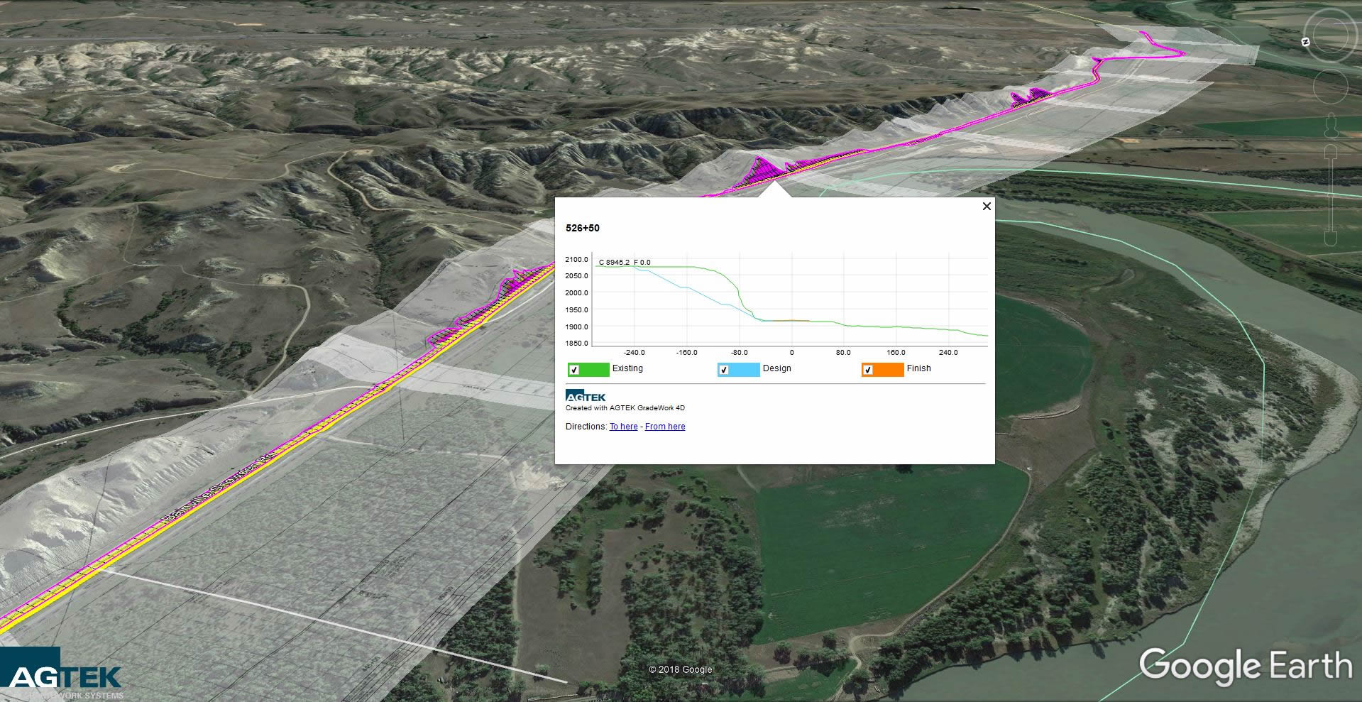
Import DOT survey and design files or enter cross sections and alignments on-screen from TIF, PDF or CAD. Highway creates a 3D representation of the job that can be readily partitioned into the construction phasing required for traffic control, and analyzed as an interactive mass diagram that identifies balance intervals, optimizes locations for borrow and spoil, calculates haul slopes and differentiates dozer, scraper and truck dirt.
Tightly integrated with Gradework, Highway models existing ground, proposed design and all intermediate surfaces, accounts for structural sections, strip, subsidence, removals and rock, and validates with graphical sections, profiles, cut-fill planviews, solid-model visualizations and dynamic drive-throughs.
Highway documents with clear, convincing tabulations and geo-referenced graphical reports that can be emailed as Pdfs, displayed on Google Earth or navigated on-site using your iPhone or Android device. And Highway exports GPS models in all commonly used formats.
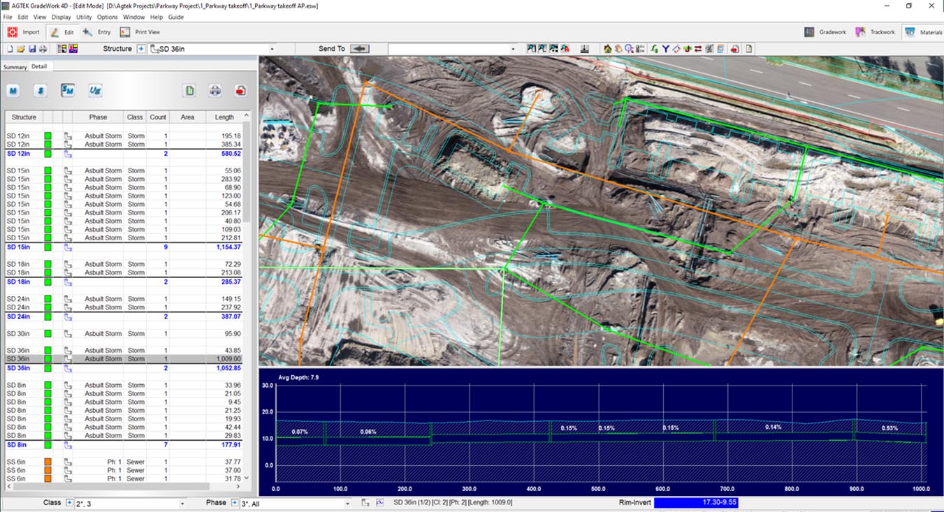
An Underground takeoff and analysis tool, AGTEK's Underground software not only documents quantities of pipe, laterals, structures and fittings, but also provides deep analysis of a project. Trench quantities include bedding, cover, select backfill and spoils. The integration with Gradework allows rapid what-if scenarios by allowing comparison to any surface. Decide whether to excavate to the lowest surface first or how trench design affects your cost. Breakout strata profiles for both volumes and in a depth bracket report. Use the drone orthomosaic image to document as-builts and progress.
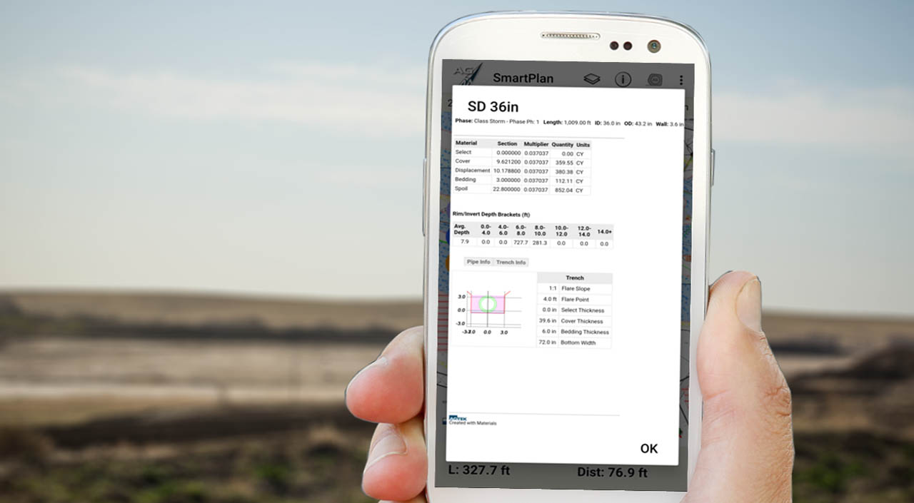
SmartPlan takes the KMZ files you've exported to Google Earth and uses that geo-referencing to create walkable plan sheets and grid maps over backgroud street or satellite maps. Add to that the ability to bring up takeoff details and document with pictures, tracks, notes. Cloud connectivity and site licensing means anyone in your company with an IOS or Android device can take advantage and share documentation
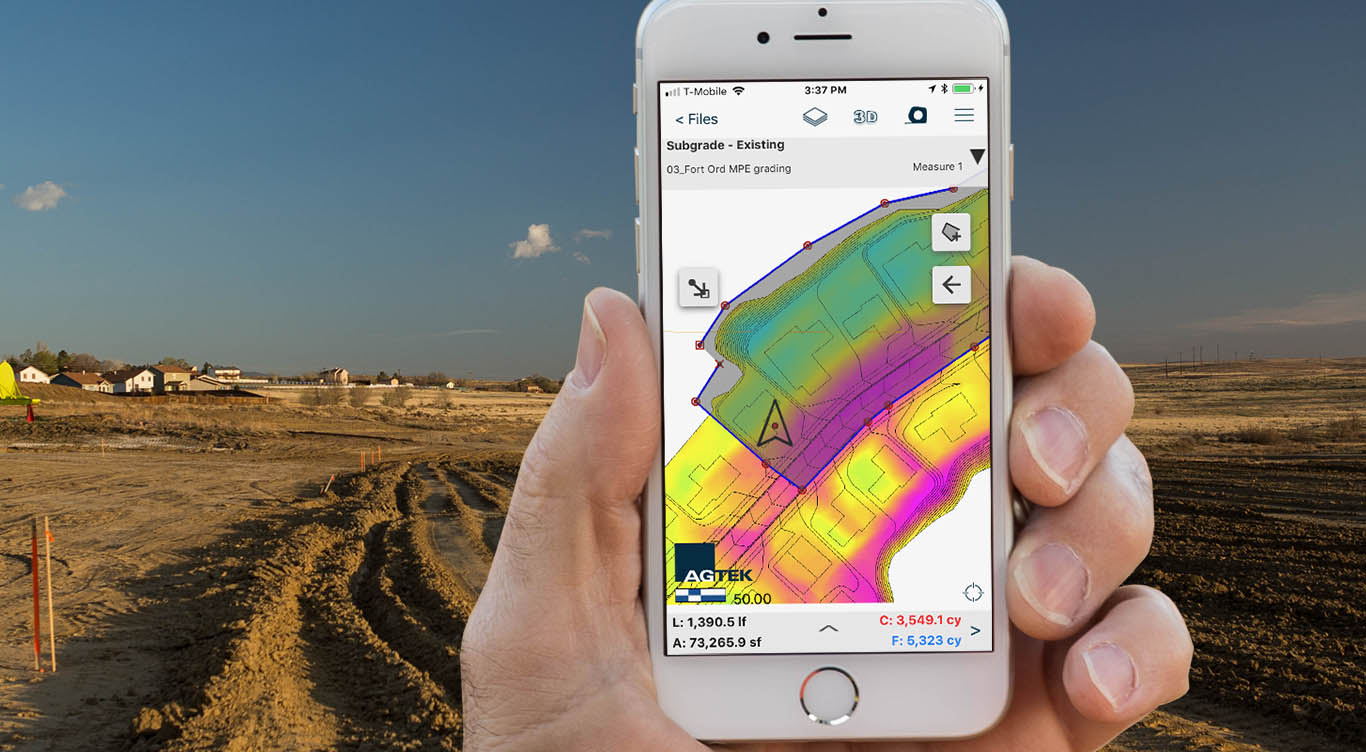
Designed for a dirt foreman, SmartDirt uses the 3D model developed for takeoff or machine control modeling and puts it on your phone or tablet. The interactive grid map shows cut or fill where you are, provides 3D views from where you stand, and shows plan sheets or drone generated images on demand based on your location. And since it's a 3D model, volumes can be measured on demand to plan hauls or document daily production. Pictures, tracks and notes are superimposed over street and satellite maps to further document whether prebid or during the project. Cloud connectivity and site licensing means that anyone with an IOS or Android phone or tablet can get what they need quickly and simply.
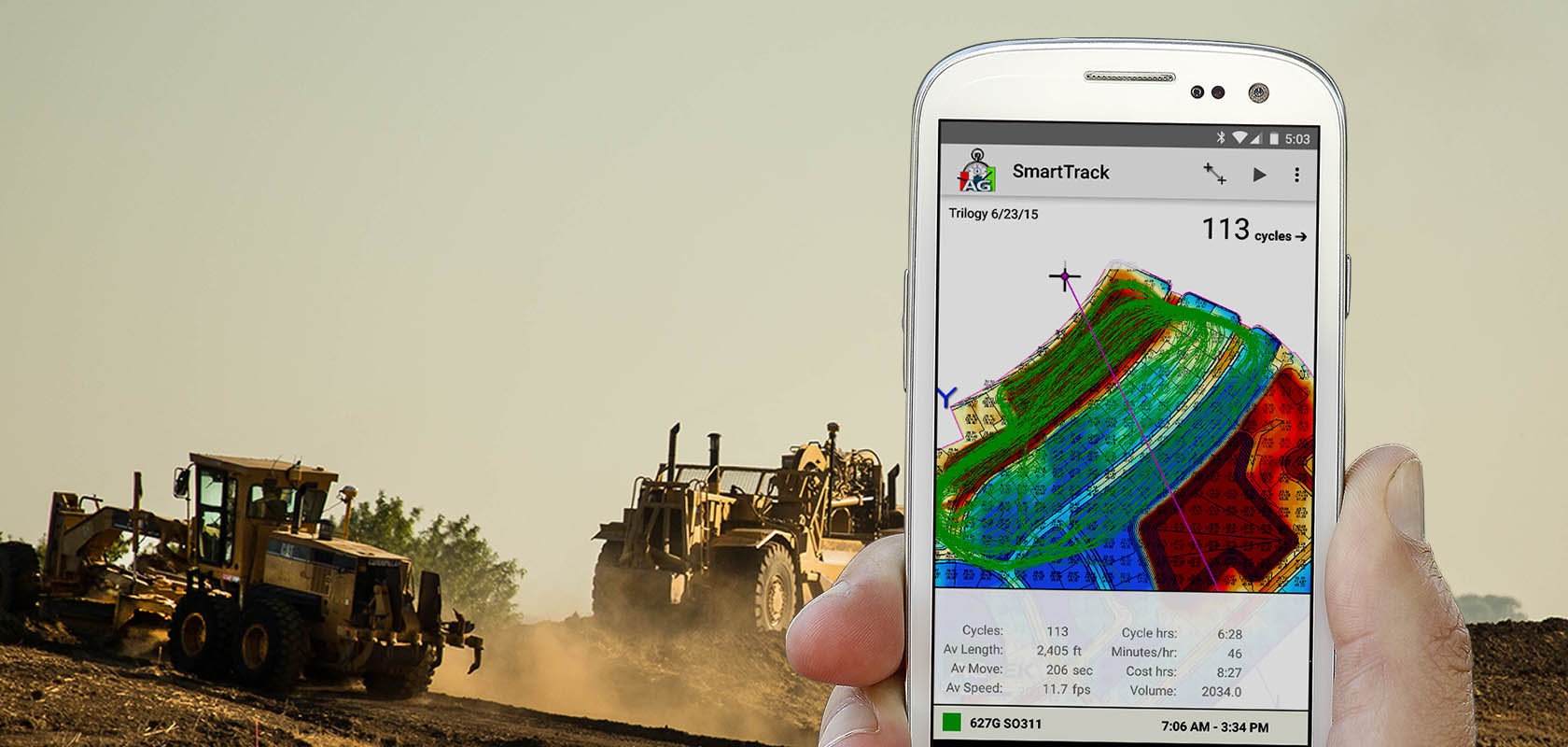
SmartTrack is a near real-time machine productivity tool for anyone that cares about job progress. Small ruggedized magnetic trackers sit on any machine that you wish to measure and update their location, path and speed once a minute. Whether on site or off this information is gathered and analyzed on the fly for fast feedback on work conditions and productivity. Valuable for the dirt foreeman running the job, the project engineer for documenting progress and billing, and the boss for decision making. Runs on your IOS or Android phone or tablet.


 Contact Us