The Dirt.Simple Express - Summer 2016
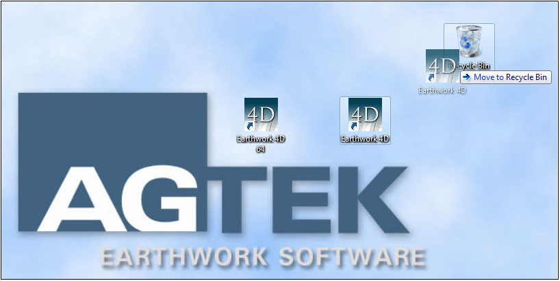
AGTEK releases version 1.18 64-bit
The latest version of Earthwork 4D, (available here) is now available in both 32-bit and 64-bit platforms.The 64-bit version will take advantage of all available memory on a 64-bit computer. This will provide the memory capacity to process larger files provided by state DOT's and engineers providing LandXML, DWG and DGN files more efficiently.

When installing the 64-bit version, a new shortcut will be created on the Desktop named Earthwork 4D 64. You may drag the previous Earthwork 4D shortcut to the Recycle Bin if desired. Click here to view a video demonstrating all the new features in version 1.18.
New KMZ Cut/Fill Grid Options
In the latest version of Earthwork 4D, the KMZ export now has an added option for the display of the cut/fill grid. When exporting the cut/fill grid to a KMZ file, the default color of the text will be black. Simply check Yes to output the cut/fill grid.

The text will display in black on the color cut/fill map. You may check Red/Blue Text if you want the text values to be printed in color, with red for cut and blue for fill. Communicate with your grading foreman to customize the grid map to their specific needs. The cut/fill map on your phone or tablet, combined with the paper cut/fill grid map gives you the control you need onsite to manage your cut/fill production.

AGTEK launches new website!
AGTEK has just recently launched its new website. Visit the website at www.agtek.com. AGTEK offers solutions for Takeoff, Modeling and Field Control, taking advantage of today’s mobile connectivity technology.

Visit the Support page to download the latest versions and view online video tutorials for all AGTEK products, contact technical support or view archived newsletters.
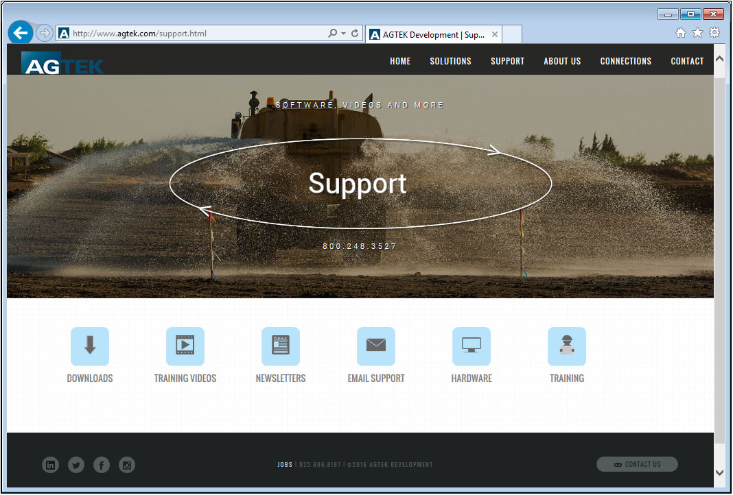
Visit the Connections page to learn more about AGTEK’s role in providing the tools for training future AGTEK users through Employer/University programs and video training courses.

Import/Export LandXML Surfaces
In the latest version of Sitework 4D, you may now import the 3D surface data from a LandXML file. All surfaces will be listed in the LandXML Import window. Check the desired surfaces to import. Click the plus beside the surface name to view the type of data in the file. The source data may include contours, breaklines and boundaries. The surface TIN may also be included.

In Sitework 4D, you may now also export the 3D surface data to a LandXML file. This file may be imported into other third party engineering or survey software. Export your GPS models to third party machine control systems. Select the File menu and select Save As. Change the file type to LandXML file. Select the desired surfaces to be exported. The XML file will contain contours, breaklines and perimeters. You may also export the surface TIN, however this option will not be selected by default.

Controlling your GPS Model
GPS machine control is becoming an integral part of many site contractors business. Generating and controlling the sitework model is an important step in successfully implementing GPS machine control. Use Earthwork 4D to build your models, or if your models are outsourced, use Earthwork 4D to verify or make any changes required after the initial model has been completed. The model controls your machines, so take control of the model with Earthwork 4D.

Put the model on your phone or tablet to be used in the field with SmartGrade for staking and layout or on a machine with SmartBlade.

|

|
Internet Key Automatic Check-in Update
The Automatic Check-In for internet keys is set to 12 hours for all users that have not modified the default check-in period. This default setting automatically resets internet keys that have been checked out for more than 12 hours. To modify this setting, your internet key administrator can change this at any time. Click here to view a short video on changing the Automatic Check-in.

Edit Fill Factor on Multiple Report Regions
The latest version of Sitework 4D now allows the user to edit the fill factor on multiple report regions. You may select the regions individually by holding the shift key on the keyboard, select by label, or select all the regions at one time. Right click and select Line Editor. Enter the desired fill factor and click OK.

Follow AGTEK on Social Media . . .
Stay connected with AGTEK using several forms of social media, including Linkedin, Facebook, Twitter and Instagram. To follow AGTEK on LinkedIn, Click ![]() here to view AGTEK's Linkedin home page, or click here to join the AGTEK Users Group. Visit our website at www.agtek.com and select the desired media
here to view AGTEK's Linkedin home page, or click here to join the AGTEK Users Group. Visit our website at www.agtek.com and select the desired media ![]() of your choice.
of your choice.
Get trained on AGTEK!
There are currently three options to receive training on AGTEK software:
- You can sign up for training via the internet and complete your one-on-one training from the comfort of your own office. All that is required is the AGTEK software you wish to be trained on and a high-speed internet connection.
- Michael Cope is an authorized independent AGTEK trainer who offers regional seminar style classes across the country.
- View the online videos to train yourself at your own pace. Click the desired program, then choose the topic.
Get Technical Support!
You may still renew your AGTEK Support Subscription. An AGTEK Support Subscription has many benefits, including:
- Access to the latest improvements and updates for your AGTEK software.
- Access to our very experienced and knowledgeable technical support through phone and email.
- Assistance with plan files in a variety of formats.
- Access to video tutorials on how to use all the power of your AGTEK software.
- Assistance optimizing your 3D site models for GPS machine control.
- Experienced GPS troubleshooting and application advice.
To sign up, please fax back your renewal letter or contact SubscriptionRenewal@agtek.com
Get current versions!
| Program | Version | Date Released |
| Earthwork 4D | 1.18.2 | 7/5/2016 |
| Materials/UG 4D | 1.14 | 5/27/2016 |
| Trackwork Analysis | 2.13 | 9/30/2013 |
| SmartPlan | 1.3.2 | 5/11/2016 |
| SmartDirt | 1.9.1 | 5/11/2016 |
| SmartGrade | 1.6 | 2/25/2016 |
| SmartBlade | 1.0.2 | 10/12/2015 |
| Earthwork 3D | 1.79.2 | 4/27/2015 |
| Highway 3D | 1.79.2 | 4/27/2015 |
| SiteModel 3D | 1.79.2 | 4/27/2015 |
| SiteModel-Highway | 1.79.2 | 4/27/2015 |
| SitePlan 3D | 1.79.2 | 4/27/2015 |
| GradeModel | 1.79.2 | 4/27/2015 |
| Materials 3D-UG | 1.67.2 | 4/27/2015 |
How do I tell what version I have?
Open the program and Select Help>About Program Name from the menu.
How do I get the latest versions?
AGTEK Support subscribers can go to the Support - Downloads page and click on the desired program. Click the Download button to start the download and save the file to a known location. When the download is finished, double-click on it to start the installation program. Follow the installer directions to completion. A backup copy of the download can be saved for future use.
If you are not an AGTEK support subscriber, please click to ask for more information.